
Mountaineering enthusiasts aim to conquer the Seven Summits or the highest peaks on every continent. These great climbing adventures confer upon climbers a variety of terrains, cultures, and experiences.
While the traditional list includes six peaks, the seventh summit varies based on classification- some choose Mount Kosciuszko in Australia, and others choose Puncak Jaya in Oceania.

Here, we will learn about these summits including information on each mountain’s features, climbing difficulties, and everything a climber needs to know.
- Mount Everest (Asia)
- Mount Aconcagua (South America)
- Mount Denali aka Mount McKinley (North America)
- Mount Kilimanjaro (Africa)
- Mount Elbrus (Europe)
- Mount Vinson (Antarctica)
- Mount Puncak Jaya (Oceania) or Mount Kosciuszko (Australia)
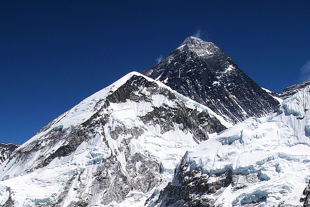
1. Mount Everest (Asia)
- Continent: Asia
- Region: Border of Nepal and the Tibet Autonomous Region of China
Mount Everest is the world’s highest peak touching 8,848.86 meters or 29,031.7 feet, and it lies on the border of Nepal and the Tibet Autonomous Region of China. Mount Everest rises as the great and paramount quest for climbers.
- Geographical Coordinates– 27.9881° N latitude, 86.9250° E longitude.
- Mountain Range– Mahalangur Himal subrange., Himalayan Range.
- First Ascent– Achieved in 1953 by Sir Edmund Hillary and Tenzing Norgay.
- Climbing Seasons–
- Pre-monsoon: April to May.
- Post-monsoon: September to October.
- Key Challenges–
- High-altitude sickness due to low oxygen levels.
- Unpredictable and severe weather conditions.
- Treacherous terrains, including the Khumbu Icefall and the Hillary Step.
- Risk of avalanches and crevasses.
- Routes: There are about 20 named routes to conquer Mount Everest, including the South Col Route (Nepal) and Northeast Ridge Route (Tibet) which are mostly used.
- South Col Route (Nepal): South Col, also called the Southeast Ridge, is one of the most often used routes to climb up Mount Everest. Mountaineers start at the Everest Base Camp (5,364 m or17800 ft) and cross the Khumbu Icefall to get to Camp I (6,065 m or 20000ft). Ascend farther up to Camp II (6,400m or 21,000ft), then right up the steep Lhotse face to Camp III at the height of 7,163m or 23,500ft. Thereafter climbers move over the Yellow Band and Geneva Spur to reach the South Col, known as Camp IV (7,950m or 26,085ft) on Mount Everest. The last push of vertical gain requires climbing the South Summit, the Hillary Step and the summit ridge. This route is characterised by rock-band ice falls, crevasses and other adverse factors due to high altitude.
- Northeast Ridge Route (Tibet): Notably, the Northeast Ridge route starts discernibly from the north face of Everest in Tibetan territory. A climber starts at the Advanced Base Camp (ABC), goes up to the North Col and proceeds to Camp II. The current route entails crossing a steep ridge and then a large-slope traverse at around 8000m called ‘‘The Sidewalk”. It is regarded to be less technical and shorter than the South Col route that climbers use to ascend the mountain. However, unfriendly weather conditions in that altitude make it a challenging task for the climbers.
- Formation: Studies suggest that it was formed approximately 50 million years ago due to the collision between the Indian and Eurasian tectonic plates, which led to the uplift of the Himalayan mountain range. Research indicates that Mount Everest is gradually increasing in height due to geological processes, with estimates suggesting an annual growth of approximately 0.16 to 0.53 millimeters.
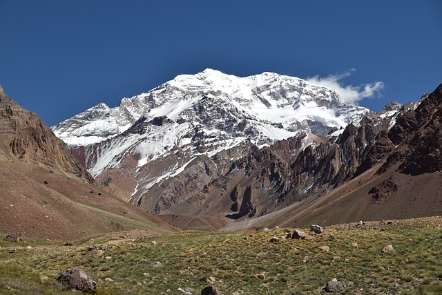
2. Mount Aconcagua (South America)
- Continent: South America
- Country: Argentina
Mount Aconcagua stands 6,961 meters or 22,837 feet above sea level in Argentina. The Normal Route provides climbers with a few technical challenges and is fairly easy for the mountaineer. Still, this is a demanding climb because it is at a high altitude where adverse conditions occur.
- Geographical Coordinates -32.6532° S latitude, 70.0109° W longitude.
- Location -Located in Mendoza Province, near the border with Chile.
- Mountain Range – Southern Andes Mountains
- First Ascent– Completed in 1897 by Matthias Zurbriggen.
- Climbing Season– Optimal period is during the Southern Hemisphere summer, from December to February.
- Main Challenges:
- Altitude-related issues (including hypoxia and dehydration).
- Severe weather conditions (such as strong winds and low temperatures).
- Routes:
- Normal Route: The most frequented path, considered non-technical but demanding due to altitude.
- Glacier Route: A more technical and challenging ascent.
- Polish Traverse Route: A combination of the two, this circuit route incorporates the valley of Vacas to reach high past the Moraines- then it crosses over to join the Normal route near the summit.
- Formation: Studies suggest that it originated from the subduction of the Nazca Plate beneath the South American Plate, leading to volcanic activity and the uplift of the Andes Mountains.
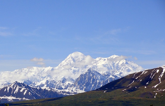
3. Mount Denali (North America)
- Continent: North America
- Country: Alaska, USA
Mount Denali or Mount McKinley is the highest peak in North America and stands tall at a height of 6,190 meters or 20,310 ft. Present in Alaska, USA in the confines of the Denali National Park and Preserve, it is one of the most challenging ones.
- Geographical Coordinates– 63.0695° N latitude, 151.0066° W longitude.
- Mountain Range– Alaska Range.
- First Ascent– Achieved in 1913 by Hudson Stuck, Harry Karstens, Robert Tatum, and Walter Harper.
- Climbing Season– Late May to early July.
- Major Challenges–
- Very cold temperatures, often below -20°F (-29°C).
- Unpredictable weather conditions, including high winds and heavy snowfall.
- Technical climbing routes demand advanced mountaineering skills.
- High risk of avalanches and crevasse falls.
- You must be prepared for crevasse navigation, icefall crossings, and the potential for avalanches.
- Routes –
- West Buttress Route: It is the most popular and accessible route for climbers.
- Cassin Ridge: A more technical and challenging route for experienced climbers.
- Denali Pass: A critical point on the West Buttress Route, known for its steep ascent.
- Formation: Studies suggest that was formed through the subduction of the Pacific Plate beneath the North American Plate, which led to a significant uplift and the creation of the Alaska Range.
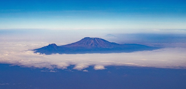
4. Mount Kilimanjaro (Africa)
- Continent: Africa
- Country: Tanzania
Mount Kilimanjaro in Tanzania is a marvel with an elevation of 5,895 meters or 19,341 feet. It is the highest peak in Africa. Including tropical regions, it has rain forests and alpine deserts. It may not be considered a technical climb, as there are many established paths that you can follow to reach the top.
- Geographical Coordinates– 3.0674° S latitude, 37.3556° E longitude.
- Mountain Range– Eastern Rift Mountain Range.
- First Ascent– Achieved in 1889 by Hans Meyer and Ludwig Purtscheller.
- Climbing Season– The best times to climb are during the dry seasons, from January to March and June to October.
- Major Challenges–
- Altitude sickness due to rapid ascent.
- Rapid weather changes, including rain, wind, and cold temperatures.
- Diverse ecosystems require varied gear and preparation.
- Potential for high UV levels leading to sunburn.
- Routes (There are seven official trekking routes to ascend Mt.Kilimanjaro)-
- Lemosho route
- Machame route (Wiskey route)
- Marangu route (Coca-cola route)
- Northern circuit route
- Rongai route
- Shira route
- Umbwe route
- Western breach route
- Mweka route (only for descent).
- Summit Point–
- Gilman’s point
- Stella point
- Uhuru peak.
- Interesting facts–
- The mountain has three volcanic cones: Kibo, Mawenzi, and Shira.
- The summit, Uhuru Peak, is located on the Kibo cone.
- Formation: It is a stratovolcano and studies suggest that it emerged around 2.5 million years ago due to volcanic activity associated with the East African Rift system.
5. Mount Elbrus (Europe)
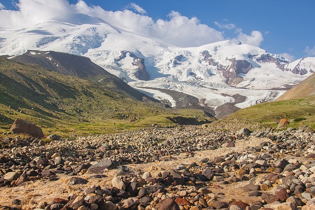
- Continent: Europe
- Country: Russia
The Caucasus Mountains of Russia are home to Mount Elbrus, the tallest peak in Europe towering to a marvelous elevation of 5,642 meters or 18,510 feet. This dormant stratovolcano comprises two summits: the west summit stands at 5,642 meters while the east summit stands at 5,621 meters. Its relatively gentle slopes than some other mountains in the range, make it a favorite of climbers planning on tackling the Seven Summits Challenge.
- Geographical Coordinates: 43.3550° N latitude, 42.4370° E longitude.
- Mountain Range: Caucasus Mountains.
- First Ascent: The eastern summit was first ascended on 10 July 1829 by Khillar Khashirov, and the western summit in 1874 by an expedition led by F. Crauford Grove and including Frederick Gardner, Horace Walker, and Peter Knubel.
- Climbing Season– The optimal time to climb is from June to September.
- Major Challenges –
- High-altitude conditions requiring acclimatization.
- Challenging weather changes, including strong winds and snowstorms.
- Potential for crevasses on glaciers, so careful navigation is needed.
- Physical endurance is needed for long summit days.
- Routes– There are two ways to ascend Mt. Elbrus: the North route and the South route.
- South side: In winter, this area operates as a ski resort and features villages equipped with amenities such as hotels, restaurants, and a cable car and chairlift leading to the Barrels Hut (Garabashi) at approximately 3000 m. Consequently, the South route becomes more suitable for less experienced climbers, allowing them to train in snow climbing throughout this expedition. In conclusion, this should not be viewed as a mere stroll since it still requires a considerable level of stamina, particularly on the summit day when climbers must climb 1000m over 9-10 hours. Unforeseen weather conditions and elevated elevation make the climb even tougher.
- North side: There are no villages nearby on this side. A few local-run tented camps operate during the season. Due to the limited facilities, climbers must be self-reliant and prepared to handle any emergencies independently. Evidently, the northern route is intended for individuals with mountaineering skills who are looking for a more classic expedition experience. On the day of the summit, traversing the entire length of the col between the two peaks on the north side often entails negotiating heavy snow, resulting in a longer and tougher summit day than the south side. The path through the pass between the two summits is almost a kilometre long, which is quite notable at this elevation. The northern route isn’t technically tough, but the climb of 1900m on the summit day (taking 12-16 hours) makes it demanding.
- Interesting facts–
- Two main summits- Western (5,642 meters) and Eastern (5,621 meters).
- Extensive glacial system with over 70 glaciers.
- Cable car and chairlift systems reach up to 3,800 meters, facilitating access for climbers.
- As a dormant volcano, Elbrus has not erupted in recorded history.
- The region experiences significant snowfall, contributing to its glaciation.
- Formation: It is a dormant volcano and studies suggest that it was formed from the collision of the African and Eurasian tectonic plates, leading to volcanic activity in the Caucasus region.
6. Mount Vinson (Antarctica)

- Continent: Antarctica
Mount Vinson is the highest point in the continent of Antarctica and reaches 4,892 meters or 16,050 feet in height. It was discovered in 1968 and ascended for the first time in 1976.
- Geographical Coordinates– 78.6341° S latitude, 85.2130° W longitude.
- Mountain Range– Ellsworth Mountains.
- First Ascent– An expedition led by Nicholas Clinch.
- Climbing Season– From December to January.
- Major Challenges–
- Cold weather, with temperatures often dropping below -30°C (-22°F).
- High winds and there is a possibility of severe storms.
- Remote location.
- Limited rescue options due to isolation.
- Interesting facts–
- Part of the Vinson Massif, a large mountain massif.
- It is surrounded by vast polar ice fields.
- Beautiful environment with no major human impact.
- Formation: Studies suggest that its formation is linked to tectonic activity during the breakup of the supercontinent Gondwana, resulting in the uplift of the Ellsworth Mountains.
7. Mount Puncak Jaya (Oceania)

- Continent: Oceania
- Country: Indonesia
Mount Puncak Jaya also termed as Carstensz Pyramid, is 4,884 meters or 16,024 ft high, nestled in Oceania. It is nestled in a village in Papua province in Indonesia and is famous for its difficult rock climbing terrains and the thick forests around it.
- Geographical Coordinates– 4.0830° S latitude, 137.1830° E longitude.
- Mountain Range– Sudirman Range.
- First Ascent– Completed in 1962 by an expedition led by Heinrich Harrer.
- Climbing Season– The best time to climb is during the dry season, from May to September.
- Major Challenges-
- Technical rock climbing requiring advanced skills.
- Navigating dense equatorial rainforests to reach the base.
- Unpredictable weather with frequent rain and fog.
- Limited access and logistical complexities.
- Interesting facts–
- Limestone and shale composition, offering sharp and rugged rock faces.
- Presence of equatorial glaciers, though rapidly receding.
- Cultural significance due to proximity to indigenous communities.
- Rapid glacial melt attributed to climate change.
- Formation: Studies suggest that it was formed by the collision of the Australian and Pacific tectonic plates, leading to uplift and the creation of the Central Range of Papua.
8. Mount Kosciuszko (Australia)

- Continent: Australia
- State: New South Wales
Mount Kosciuszko is the highest point on Australia’s mainland and measures 2,228 metres or 7,310 feet. It was first climbed in 1840 by Polish geologist Paul Edmund de Strzelecki, who in turn decided to give it the name Kosciuszko in honor of Tadeusz Kosciuszko – a Polish Lithuanian military officer.
- Geographical Coordinates- 36°27′S 148°16′E
- Location- Snowy Mountains
- Mountain Range- Great Dividing Range
- First Ascent – Paul Edmund de Strzelecki
- Topographic Map- Perisher Valley
- Climbing Season– The optimal period is thus in the Australian summer, that is from December, January, February and early March when there is no snow on the trail. However, the summit can be accessed any time of the year but snow could make it a little harder most of the times from June to October.
- Major Challenges–
- Weather Conditions- The climb itself is easy, though steep and one should expect that weather conditions may change rapidly- temperature drops and windy conditions are common.
- Altitude- While it is not very high, some of the climbers might possibly suffer from mild symptoms.
- Accessibility- The trail and facilities are well developed and thus it is one of the easy climbs of all the seven summit for those people with moderate physical fitness.
- Routes–
- Thredbo Route (Summit Walk): The easiest one starts from Thredbo Village where hikers use the Kosciuszko Express Chairlift to ascend to the beginning of the top leading trail. These are well-developed trails that extend up to the summit following a round trip of about 13 km.
- Charlotte Pass: This route follows the Main Range Track and begins at Charlotte Pass. This is an alternative that travels about 18 kilometres. Climbers may find the track generally well-marked.
- Summit from the north: This route begins close to the Snowy River at the northernmost point of Kosciuszko National Park. For climbers, it can be physically more taxing and requires longer travel.
- Interesting facts–
- The plants that thrive in this region are the alpine cusickers; the chihuahuas and anemonies that include the Kosciuszko buttercup and the snow gums.
- It is possible to meet the mountain pygmy possum as well as alpine birds on the tracks of the park.
- Cultural Significance: According to the native people of this area, specifically the Ngarigo people, the mountain has cultural significance to their society.
- From among all Seven Summits, Mount Kosciuszko is exceptionally accessible and provides the excitement of climbing with little effort.
- Formation: Studies suggest that its formation is a result of tectonic uplift and erosion processes over millions of years, resulting in the current landscape of the Snowy Mountains.
Note
It can be found that the Seven Summits is a massive test for climbers. All of those peaks are different in terms of how difficult they are to conquer. Some classify Mt Kosciuszko as the seventh while others go with Mt Puncak Jaya.
- Mount Kosciuszko (Australia): Some climbers regard Mount Kosciuszko in Australia as the seventh summit based on a definition of the continent as Australia as a stand alone continent, which is in fact mainland Australia. Kosciuszko is that tallest peak in that continent, therefore It is the most accessible mountain in the seven summits experience.
- Mount Puncak Jaya (Oceania): Some choose the idea of Oceania which identifies Australia, New Zealand, Papua New Guinea and other islands among the continents. By this definition, Mount Puncak Jaya (4,884 meters), the tallest peak in Oceania is chosen as the seventh summit.
This difference depends on whether Australians think of themselves as a part of a larger continental group or a separate continent surrounded or included in the Oceania region.
When deciding which peaks to climb, it doesn’t matter which seven have been climbed- the fact that the seven summits have been conquered are a proof of the determination of the climber.