+91 9051055011 | +91 8969336262 info@meandmountain.com

Login

Sign Up

After creating an account, you'll be able to track your payment status, track the confirmation and you can also rate the tour after you finished the tour.
Username*
Password*
Confirm Password*
First Name*
Last Name*
Birth Date*
Email*
Phone*
Country*
* Creating an account means you're okay with our Terms of Service and Privacy Statement.
Please agree to all the terms and conditions before proceeding to the next step

Already a member?

Login

Rupin pass trek

0
Moderate to Difficult
Booking Form
Enquiry Form
Full Name*
Email Address*
Travel Date*
People*
Your Enquiry*
* I agree with Terms of Service and Privacy Statement.
Please agree to all the terms and conditions before proceeding to the next step

Available dates:
10-05-2025
07-06-2025
13-09-2025
11-10-2025

CUSTOMIZED:
Fees based on the final number of participants. Kindly contact +91-9051055011/ +91-8969336262 for the further detail before proceeding for the payment.

You will be directed to the secured payment gateway on clicking the button.

Proceed Booking

Proceed Booking

Save To Wish List

Adding item to wishlist requires an account

303

[trustindex no-registration=google]

7 days
Availability : 10-05-2025, 07-06-2025, 13-09-2025, 11-10-2025
Jiskun
Sangla
Min Age : 16+

Glimpse of Rupin pass trek:

Location: Himachal Pradesh

Duration: 7 Days/ 6 Nights

Trek gradient: Moderate to Difficult

Maximum Altitude: 4,650 m (15,279 ft) above sea level

Distance: 52 Km

 Pickup/ Drop Point: Jiskun/ Sangla

Best Season: May-June, -September to October

Temperature: Summer (May-June): 15˚to 20˚(Day); 3˚to-2˚(Night)

   Post-Monsoon (September-October): 13˚to 20˚(Day); 5˚to -2˚(Night)

Customized fees:
Fees based on the final number of participants. Kindly contact +91-9051055011/ +91-8969336262 for the further detail before proceeding for the payment.
Overview of Rupin pass trek

If you want to be mesmerised by beauty at every turn you take, the Rupin pass trek is the trek for you. Known for its waterfalls, snow bridges, lush forest, Temples, hanging villages and grand views of Kailash, there is something for everyone to enjoy. Unlike other treks, the Rupin pass trek is known for its change of sceneries and is ought to keep you on edge as you keep exploring new sights and sceneries.

Rupin pass is a high altitude(15000 ft) trek in the Himachal with a difficult trek gradient, it Starts at Dhaula, Uttarakhand and ends at Sangla. From rocky terrain to snow, from gentle streams and water-falls to vast lush green meadows, from sudden steep climbs to easy walks the Rupin pass is as whimsical as the wind and that’s one of the major reasons why it’s so popular and beloved by trekkers and nature lovers.

The first leg of the journey is a ride to Bawta. The weather is pleasant and the sweet mountain breeze will draw your eyes to sights along the hilly roads.

With the dawn on the next day, the real journey starts with a moderate ascent till Jiskun followed by a slight descent. With the journey continuing into the forest, wooden bridges will come in sight, From the bridge the trail gets steeper and ascends in a zig-zag pattern till you reach Jakha, the highest and terminal village of the trek. Rest-up and restock on supplies at Selwan Khad since it will be the last water point. Lunch will be available on the campsite and the day will end with you nicely tucked in cosy homestays. Unlike the second day the journey won’t be just 5km, we will be covering 11km in the third leg of the journey and it will take about 8 hours so be prepared and rest well.

The journey on the third day although long will mostly have gentle gradients. The journey starts with a well-defined trail, passing through the fields of Jhaka village, gradually the fields of Jhaka will be swapped with forests of lofty old fir trees. As the journey continues the forests will change into snowy patches. It is when you will come across a snow bridge that you need to cross. Following the snow bridge there will come another narrow bridge as you traverse the narrow trail. After this, the ground will change into boulders and occasional streams. After about one and a half hours of scaling this rocky terrain you will have a change of scenery as you enter another forest, this time decorated with Rhododendrons of a different colours. Another few kilometres down you will reach Saruwas Thatch, a campsite where different shades of nature blend together. Take in the beauty of the beautiful U-shaped valley in the middle of the forest with the sight of Rupin waterfall at a distance. After a bit of relaxation and admiration, move on with the journey, which is now along snowy patches, mountain sides and silver birch trees. As you move up from the forest, you will reach the lip of the valley overlooking countless waterfalls rustling through the lap of green meadows. People often say the sights almost have a hypnotic effect. From here on you will be crossing a series of snow bridges until you reach the middle of the valley, Dhanderas Thatch. This would be the campsite where you will have lunch and rest by one of the biggest meadows in the Himalayas.  

As the next day dawns near prepare for a 5km trek. But be advised, the trek of the 4th day will rapidly gain altitude. The journey will start from the base of Dhanderas, from there we will be crossing several rivulets of  Rupin. You would need to make your way up towards the first waterfall through a field of flowers, the journey almost resembles a fairy-tale as we make our way to the snow patches. From here on it’s a careful and tricky climb through a trail of rocks along the hill. At this point you will be able to make out a trail cutting through the thick snow. It’s from here that you would need to cross yet another vast Snow bridge. After you cut your way through the snow bridge and take a sharp climb you will be done for the day as your campsite welcomes you to relax as you enjoy the magnificent scenery.

The fifth day is the most exciting and longest day of the trek with steep ascends and descends along the way. The day clocks in a 12km journey in 12hrs. To accommodate for time the journey will commence very early. We will leave the campsite by 4:30 in the morning so make sure that you are well rested the day before. With supply sources being limited henceforth, make sure to pack well beforehand. The journey commences with a steep ascent and a rapid gain in altitude, after about an hour of climbing, we well come at a bifurcation from where we will take the left trail and go on to discovering new sights from Rati Pheri campsite. Vast stretches of snow-covered grounds will come into sights which you need to cut your path through this thick snow until you reach Rupin pass Gully. From here on the trail to Rupin pass is short but strict caution is advised as the snow cover will be thick and the trails not clearly defined and adding to this is the risk of falling stones from above. From there on get ready to experience the thrill of sliding down the snow to reach Rukti Gad. From there the way to Ronti Gad is but a gentle walk followed by a sharp descent. This would be our campsite for the day surrounded by snow clad mountains.

The following day as you wake up amidst the sunbathed mountains which now resembles a golden crown, roam around and take in the mesmerising aww of the nature as the sixth leg of the journey is all about rest and acclimatization before the final day of the trek.

The final day of the journey will be a downwards descent, take caution as the altitude will drop rapidly along the journey. After you make your way through sharp descents the trail will morph into a mild climb followed by a walk along a gentle gradient toward Ronti Gad valley. We will be exiting through a narrow valley and on the other side will be grand views of Mt. Kailash. Sangla Kanda lake will come into sight from here as we leave behind Rupin pass. We will make our way to the villages settled near the Sangla Kanda lake now.  On reaching the villages, rest up and take in the views of the great lake. Making our way through the forest of blue pines we will reach well defined trails descending rapidly, within half an hour you will reach Baspa village from which its just a 20 min climb to Sangla. And like all good things the journey will end there.

Highlight of Rupin pass trek

At every curve, the scene changes:

The Rupin Pass has to be considered India’s one of the most iconic trek. After each hour or so, the landscape on the trek changes and will amaze you. The trip unveils different vistas and scenery with each step. The trip travels through deep forests of  Oak, Fir, and, Rhododendron,  with breathtaking vistas.

The excitement start on the very first day of your journey. When you reach the Rupin River, which fanns out into a wide bed after about 20 minutes on the walk.  The route then passes past hanging settlements before plunging into a dense pine forest.  But wait, there’s more. After that, the route passes through icy meadows,  snowy peaks, snow bridges, glacial valleys, and  countless waterfalls.

Even though the river is visible for most for the time in the journey, it enjoys playing peek-a-boo every now and again.


Rupin River:

You’ll see the Rupin River for the first time past the village of Netwar as we move towards Dhaula from Dehradun. Underneath the shade of oak and pine trees, the river is seen squawking and winding its course all around stones. 

The route begins at Sewa and wanders down a small and uneven road that passes through diverse farmed areas and oak woodlands. For a while, you can lose track of the Rupin at this point. Then  the route dips through the woods to meet up again with the Rupin’s banks. You’ll be strolling beside the Rupin riverbed by this point. It’s best not to get too near to the bed since it’s full of pebbles and scree, and also the currents are quite powerful.


Dhanderas Thatch:

The hike rewards you with a spectacular view of the Rupin River.but thats not all, you get to see how  it comes in the form of a three-tiered waterfall that falls down to the vast U-shaped valley of Dhanderas Thatch.

The sight is exquisite, with hundreds of thin waterfalls cascading from the side slopes, giving this campground the nickname “The Land of a Thousand Waterfalls.”

While leaving Dhanderas Thatch, you’ll pass through various streams before arriving at the base of the waterfall. Then once you reach you start ascending up from the bottom to the peak of the waterfall. The ascent is difficult yet rewarding. The Upper waterfall campground is located at the top of the trail, amid a beautiful meadow right on the banks of a gently running river. Numerous mountain streams join to form the Rupin stream, which flows to the edge of this meadow before falling into the valley as the magestic Rupin Waterfall. To see a waterfall right from the top is truely a once-in-a-lifetime experience that few people can claim to have done.


Lower waterfall campsite:

The lower waterfall campground is undoubtedly one of the most beautiful one in the Himalayas. It sits on the bed of a beautiful green meadow, nestled at the bottom of a gorgeous “U” shaped glacier valley.  Snow-covered cliffs loom on all three sides at the bottom of the meadow.

The Rupin falls over two thousand feet from the snow-capped Dhauladhar mountain in front of you, forming the spectacular Rupin waterfall. It’s a treat to spend few days at this campground.


The Hanging Village:

Jhaka Villgae, or the Hanging Village, is a well-established village which is oddly situated  on the brink of a mountain range, giving it the appearance of hanging out over a cliff.

On the tough trail to Rupin Pass, this village provides a welcome sigh of relief. Hanging from a cliff, literally.   Dhara village, which is located at a higher elevation than Jhaka, displays an accurate hanging perspective of the village. Jhaka was formerly a part of Dhara, according to legends. It was moved down by a landslide and has been dangling ever since


Kinnaur Temple:

 It is a two-story Kinnauri temple in Sewa that is quite interesting. The residents and their culture are as beautiful as the village itself. That is apparent from the first instant of their welcomes. The kids of Jhaka are also used to hikers coming to see them and are rather amusing and friendly. A magnificent Kinnaur temple stands in the sparsely inhabited village, displaying its rich past. This beautiful town is the ideal campsite during walk from Bawta to Jhaka.


Snow Bridges:

 The walk includes multiple snow bridges, and seeing these bridges entirely coated in snow in the heart of the Himalayas is truely a sight to behold. The Rupin River provides another surprise for the travelers who come from Jiskun to Buras Kandi. The surprise comes in the form of a beautifully huge snow bridge that arises out of nowhere after a long trip through the woods. As you approach the lush meadow of Udaknal, the Rupin River changes its shape once more. The river will be ambling along quietly midst of the meadow this time. Buras Kandi’s meadows is an hour away from here, situated against a background of vibrant Rhododendron trees.


Views of Kinner Kailash:

 The majestic Kailash Peak offers a stunning vista that s enough to leave you mesmerized by the charm of the Rupin Pass Trek. Kinner Kailash, also termed as Kinnaur Kailash, is a peak in the Kinnaur district of Himachal Pradesh, India. This mountain  is 6050 metres high and is worshipped by both Hindus and Buddhists in Kinnaur. According to common belief, Goddess Parvati herself formed the kund as  it was the meeting place of Lord Shiva and the goddess. According to another mythology, Lord Shiva used to convene a gathering of gods and goddesses right here at Kinner Kailash every winter.


Better trekking game:

The Rupin Pass, with an altitude of 4,650 metres above sea level, is still a moderate-level trek ideal for travelers who have already completed an easy trek and want to level up their game. Even though the daily distances covered are fair and the height rise on the trek is consistent, the path does pose some challenges that necessitate a special set of abilities to successfully manage its environment. Nevertheless, it allows you to see Mussoorie’s tourist attractions, including Damta,  Purola, Kempty Falls, and Naugaon, .You can add the climb of Rupin Pass which is 15250 feet to your list of achievements, and enjoy the spectacular views of the Kinnaur Kailash Range and the Rupin River, which you will observe during the route.The journey brings you to two of India’s most picturesque hill stations, Mussoorie and Shimla, adding to the excitement and adventure factor.

Pick up location

Drop Location

Jiskun, Himachal pradesh

Sangla, Himachal pradesh

Price Includes

  • Transportation from Shimla to Jiskun & Sangla to Shimla
  • Camping accomodation during trek on sharing basis
  • Camping essentials: Dome Tents, Kitchen tent, Toilet tent (traditional pit style), Harness & Carabineers
  • Breakfast, Lunch, Evening tea, Dinner during trek.
  • Guide, Group Porter, Cook, Helper
  • Stretcher evacuation
  • Portable Oxygen cylinder, Pulse oximeter, BP apparatus, Infrared thermometer & other staffs
  • Permits

Price Excludes

  • Travel Insurance
  • Food during drive to & fro Shimla
  • Off-loading during the trek (can be arranged on cost as per local tarrif)
  • In an event of a trekker deciding on discontinuing the trek midway due to any circumstance/ evacuation, he/she will be escorted till the nearest road end from where the further expenses of transportation, hotel/ hospital and food shall be managed and borne by that trekker. In such unfortunate event the trekker won’t be eligible for the refund.
  • Personal trekking gears like Sleeping bag (can be arranged on extra cost), Gum boots, trekking poles, toiletry and other items mentioned later in things to carry section.
  • Any cost escalation (accommodation, food, transportation) due to unforeseen circumstances like landslides, roadblocks, bad weather, pandemic crisis, sudden government policies or regulations
  • Any expense arising out of itinerary will have to be borne by the Trekker
  • Gratuity/ Tip
  • If the the weather condition remains favourable throughout the trek and buffer day is not utilized henceforth the trekker completing the trek in 6 days, the cost of accomodation and fooding for the rest of the stay will be borne by the trekker.

Advisory

  • Always carry a valid original photo ID card with you.
  • Trekking is an activity where there are more than 50% chances of facing uncertainty, as you see it’s mentioned “Tentative” itinerary. Weather conditions, wildlife movements, permission changes can often force the trek leader to change the itinerary, distance or place.
  • Throughout the trek, starting from the pick up to the drop, the final decision will be taken by the trek leader and all the trekkers will be expected to abide to the same.
  • All participants are expected to have a fitness level, stamina and the ability to sustain harsh environments.
  • Every trekker will have to undergo a temperature and other vitals check every day.
  • Do weigh your Gears post packing. It should not exceed the range of 8-10 kg – preferably on the lighter side.
Booking terms
Confirmation policy
  • Email on booking@meandmountain.com or WhatsApp on +91-9051055011 the following details: Name of the participant(s), Name of the event, Date of the event, Email address (Note: This is not the Enrolment form) and proceed with the online payment either via the payment link shared via WhatsApp or the payment section on the website.
  • Mode of payment: only online
  • The participants will receive the Confirmation email and Ticket via email within 48 hours.
  • Ater the confirmation, you will need to send the dully filled, signed and scanned forms (Enrolment, Medical & Self-declaration) to booking@meandmountain.com, before commencement of the expedition.
  • The forms can be downloaded from the links below or ‘FORMS’ section in the home page.
  • It is mandatory for all the participants to submit all 3 forms before the expedition, in absence of which Me and Mountain shall have a full right to deny the entry of that participant to the particular expedition.
Cancellation policy
  • Cancellation done any time after the booking of the event shall be adjusted in any event later with ‘Me And Mountain Global Adventures Pvt Ltd’ only via Adjustment voucher. The Adjustment voucher will be valid for 1 year from the date of the event cancelled.
  • Refer the section on Cancellation/Refund Policy for the detail cancellation policy.
Discontinuation policy
  • In an event of a participant deciding on discontinuing the event mid-way due to any circumstance other than medical condition requiring emergency evacuation, he/she will require to do so by signing the ‘Discontinuation form’ after which he/she is set to go on own. In such situation the participant will neither be eligible for the Refund or the Adjustment voucher.
Forms
Reaching Basecamp

Reaching Shimla

  1. Bus Route:

You must take an overnight bus to Shimla and then a cab to the pickup location.

We usually advocate taking government buses rather than private buses outside the bus terminal since, in our experience, there is a considerable risk of delay with private buses. Furthermore, government buses are always more dependable. Whatever bus you choose, make sure you get in Shimla by at least 05:30 a.m.

  1. Train Route:

You may take a train to Kalka and then drive to Shimla, or you can experience the pleasure of a toy train. If you are travelling by rail, it is advised that you arrive one day early.

  1. Flight:

You may take flight to Shimla airport i.e Jubbarhatti airport. If coming by flight then you have to come one day early.

Tentative Itinerary
May change as per the local authority permission & availability of accommodation

Day 1Reach Jiskun from Shimla

  • Altitude: 7,700 feet
  • Time taken: 10-11 hour drive from Shimla

Jiskun (7,700 ft) serves as the starting point for the Rupin Pass hike. It’s a nice place, and there are local stores where you can obtain rice, wheat, sugar, spices, and veggies.

The route passes via Rohru, where the road divides in two. One road leads to Janglik, the starting point for the Buran Ghati trek, and the other to Jiskun. The road to Jiskun passes via the stunning Chainsheel valley, which is a trip in and of itself. We’ll be here all day.

Day 2Jiskun to Udaknal

  • Altitude: 7,700 ft (2,347 m) to 10,318 ft (3,145 m)
  • Time taken: 6 hours, 8-7 km

We’ll be trekking to Udaknal today. Jakha, the highest and final settlement on the Rupin pass hike, is a 3.5-kilometer walk away. The route quickly dips into a deodar and walnut woodland. We’ll climb for an hour to get to Jakha. The route begins by zigzagging up the slope’s ridge line. The path passes through a beautiful mixed woodland and ascends to Dhara, a town higher than Jakha. The campground is located slightly above the town. 

Jakha is our final stop before reaching Sangla to refill our supplies. The well-marked path ascends beyond the playground, passing through upper Jakha village fields before entering a spectacular fir forest.

Cliffs hang over the V-shaped valley on the other side of the route, high above. The first spots of snow appear in their crags. The biggest surprise of the day comes an hour into the downward trek through the fir forest. A long snow bridge stretches across the Rupin.

We’ll stroll to the snow bridge, feeling the snow under our boots. Then we’ll ascend to the upper reaches of the snow bridge, cross the Rupin, and rejoin the route on the other side. We’ll continue the route until we reach a wooden bridge. The first open grassland in Udakanal lies further up, to the right of the bridge.

We’ll trek for an hour, passing streams and stones. We’ll come to a tiny open grassland just before the route enters the trees. Burans Kandi here. We’ll eat some meal and spend the night in our tents.

Day 3Udaknal to Dhanderas thatch (lower waterfall camp)

  • Altitude: 10,318 ft (3,145 m) to 11,700 ft (3,566 m)
  • Time taken: 4 hours, 4.6 km

We’ll be heading to Dhandras Thatch today. The Rupin rages on below. Massive snow patches fill the valleys that were previously glaciers on the other side.

The ascent is strenuous. The Rupin next to us is fast ascending in a sequence of mini-water falls. The ascent isn’t going to last long. We’ll be surrounded by thousands of Rhododendrons in full bloom in ten minutes.

The trek for the day is maybe one of the greatest you’ll ever take. The sight of the Rupin bursting out of a canyon right ahead and to your left is what makes Saruwas thatch so beautiful.

We’ll make our way through the woods and shrubbery to a lush green amphitheatre. As you look down from the valley’s rim, you can see thousands of waterfalls pouring down its brown sides to reach the Rupin. And the Rupin elegantly weaves its way down from its source through the rolling fields. Topping off the beauty are white snow patches spread around the margins of the meadows.

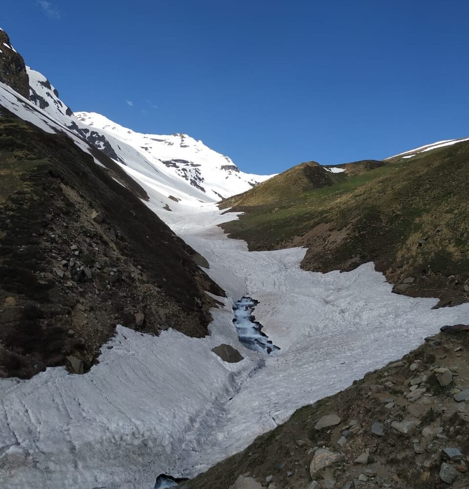
Then we’ll descend through the valley of golden marigolds, enjoying the easy sloping walk until our first challenge: a snow bridge across the Rupin. Crossing the snow bridge is simple, and we’ll soon be on the Rupin’s left bank. The walk moves gently through the lushness of the meadows.

We’ve arrived in the most beautiful meadow of the journey. The Rupin is running down its three tiers of waterfall ahead. The alpine Dhauladar Range looms towering behind the waterfall. The icy valley cliffs with their countless waterfalls surround you on all sides. We will pitch our tent and enjoy the most magnificently designed grass that nature has to offer. Dhanderas Thatch is a magnificent location. We’ll eat dinner and spend the night in tents here.

Day 4Buffer day

A buffer day will be utilized in case of unfavourable weather to move ahead. We have mentioned the buffer day on day 4 but it can be utilized on any day of the trek as per the requirement. If we are fortunate to have a favourable weather throughout the trek, we won’t be utilizing this buffer day and will be reaching Sangla on Day 6. 

Note: If the the weather condition remains favourable throughout the trek and buffer day is not utilized henceforth the trekker completing the trek in 6 days, the cost of accomodation and fooding for the rest of the stay will be borne by the trekker.

Day 5Dhanderas thatch to Upper Waterfall camp

  • Altitude: 11,700 ft (3,566 m) to 13,385 ft (4080 m)
  • Time taken: 3 hours , 2.4 kms

We’ll be going to the Upper Waterfall Camp today. This is maybe the most significant day of our journey. The acclimatisation climb to the top of the waterfall will be extremely beneficial for a successful ascent to the Rupin pass.

Unlike most days, we will start the day casually. We’ll get ready for the trek to the top of the waterfall after breakfast.

Dhanderas Thatch is roughly a kilometre away from the waterfall’s base. There will be lots of streams to hop and leap over along the route, as well as a riotous display of yellow marigolds.

When you approach the snow patch at the foot of the waterfall, things start to get serious. Instead of climbing directly onto the snow spot, climb against its side on the boulder until you reach the trail that crosses over the snow patch. A trekking pole for support would be a good idea. An ice axe is highly useful in this situation. We’ve arrived at the top of the lower water fall.

Before we get to the large snow bridge across the Rupin, we have to go through another series of snow patch crossings and sporadic rises. We are now over the middle water fall.

Crossing over the Rupin is a difficult climb flanking the hillsides that climbs to the peak of the waterfall. It feels like you’re climbing a succession of ledges before reaching the meadow at the top of the waterfall.

For the first time, you get a glimpse of what it’s like at the top of the waterfall. It’s a broad grassland that reaches out to a flat basin. The Rupin is formed by streams that converge on the basin from the alpine snowy side. We’ll spend the night here.

Day 6Upper Waterfall camp to Rupin Pass via Rati Pheri, further on to Ronti Gad

  • Altitude: 13,385 ft (4080 m) to 15,279 ft (4,657 m) to 13,139 ft (4,005 m)
  • Time taken: 10-11 hours , 7.4 kms

We’ll start the day before the sun comes up and depart the camp by 5:00 a.m. We’ll need to bring food for an energy boost during our quick stop at the top of the pass.

The path to Rati Pheri begins to the left of the meadow. We’ll ascend sharply along what appears to be a mile-long snow area. After about an hour, the slope turns left and opens out to the Rati Pheri camping sites.

For the first time, you can see the Rupin pass, a little breach in the Dhauladar ridge line, from Rati Pheri.

There are no traces on the snow, so keep an eye out for the Rupin Pass gully. We will arrive at the foot of the Rupin pass gully after an hour and a half of difficult hiking. We must climb in a single file and position our feet in the depression of the footstep in front of us. As we make our approach to the bottom of the gully, keep an eye out for falling stones and rocks.

When we glance up to the gully’s mouth, we will see a slew of prayer flags fluttering in the powerful winds that sweep across. The Rupin pass is available.

The ascent through the gully is exhilarating. It shouldn’t take more than fifteen to twenty minutes to reach the pass’s summit.

The pass is a saddle on a ridge that runs through and across the Dhauladar range. You get your first glimpse of the Sangla side of the mountain. The picturesque view will move you.

The descent on the Sangla side is steep, and the only area to camp is in the huge meadows below the snowline. We’ll step out of the pass and glide down the snow chutes. There is only one way down, and that is on our bottom. We’ll descend around 400 feet of height in a matter of minutes.

It takes little more than an hour to reach the snowline. Rupin pass is visible in the distance.

There is a steep drop from the snowline to the boundless meadows that reach all the way to Sangla Kanda. There is a clear, plentiful brook at the bottom of the slope.

We’ll camp at the surrounding even areas. Another approach to identify the camping area is to find the remains of an old campfire. This is Ronti Gad’s camping area, another another lush heaven on Earth.

We’ll arrive to the meadows, but the scenery will be different. The campground is surrounded by towering, snow-capped mountains. The image is a combination of snow whites and grass greens. We’ll spend our coldest night of the hike in Ronti Gad, so we’ll get into our sleeping bags early for a well-deserved snooze.

Day 7Ronti Gad to Sangla Via Sangla Kanda

  • Altitude: 13,139 ft (4,005 m) to 8,776 ft (2,675 m) via 11,427 ft (3,483 m)
  • Time taken: 6 hours , 11.9 kms.

Today we’ll make our way down to Sangla. We’ll start the day slowly, but not too slowly. The drop will cause us to lose height quickly, and it may become rather warm towards Sangla.

After an hour and a half and a 1,500-foot dip, the route leaves the Ronti Gad’s small valley, veers left, and widens out to the valley above the Rukti Gad. The snow-bound Nalgan pass, to the right, serves as a subtle reminder of a hike for another day. The abrupt emergence of the Kinner Kailash range in front of you takes your breath away.

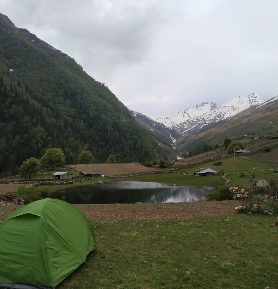
The lake of Sangla Kanda and the modest town of the village are the first evidence of civilisation. The journey to the village takes another hour and a half.

There are several pathways leading from Sangla Kanda to Sangla. Request instructions from a villager or take any route that leads right.

We’ll arrive at the bridge below the woodland rest house after half an hour and a steep drop to the Baspa beside a school with uniformed youngsters. We must navigate the choppy waters of the Baspa.

There are eateries and lodging options around the bus terminal. The final bus to Shimla departs at 5:00 p.m. and arrives at 3:00 a.m. the following day. Here comes the end of the intensely glorified trek.

Photos